


Training Course on Flood Damage Assessment Using Remote Sensing Data (May 8-12,2023)
برگزار شده
Training Course on Flood Damage Assessment Using Remote Sensing Data (May 8-12,2023)
برگزار شده
توضیحات
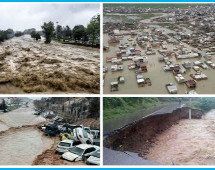
In order to improve the implementation of the “Establishing and Operating Flood Monitoring and Warning System Using Satellite Imageries” project led by Iran under the "First Batch of DSSP Application Projects", ISRC -according to the project PMP- has organized a training course entitled: “Flood Damage Assessment Using Remote Sensing Data”.
|
PRESENTER |
|
|
Mr. Abdorreza Ansari (Iran) Senior Remote Sensing Expert, Iran Space Agency |
aansari@isa.ir |
|
Mr. Dehghan(Iran) The head of the laboratory infrastructure development and standardization department |
dehghan.you@gmail.com |
|
Dr. Veerachai Tanpipat (Thailand) Hydro-Informatics Institute (HII), Ministry of Higher Education, Science, Research, and Innovation (MHESI) |
|
|
Prof. Wenlong Song (China) China Institute of Water Resources and Hydropower Research (IWHR) |
|
|
Prof. Ali Talebi (Iran) Professor, Department of Watershed Management Engineering, Yazd University, President of the Watershed Management Society of Iran |
talebisf@yazd.ac.ir |
|
Prof. Hui Lu (China) Tsinghua University,China |
|
|
Dr. Malekian (Iran) Faculty of Natural Resources, University of Tehran |
malekian@ut.ac.ir |
|
Dr. Parisa Firoozi (Netherlands) The Delft University of Technology, Department of Water Management, Faculty of Civil Engineering and Geosciences |
parisa.firoozi@gmail.com |
|
Prof. Dr. Tawee Chaipimonplin(Peru) Department of Geography, Chiang Mai University, Chiang Mai |
tawee.c@cmu.ac.th |
|
Dr. Irfan Mahmood (Pakistan) Earth & Atmospheric Remote Sensing Lab (EARL), Department of Meteorology, COMSATS Institute of Information Technology (CIIT) |